

Where is Hightsville in Wilmington, NC? Hightsville is a small unincorporated area of New Hanover County on the east bank of the Northeast Cape Fear River, just north of downtown Wilmington. It sits around Castle Hayne Road (NC 133), where that road meets the Martin Luther King Jr. Parkway. Homes here carry a 28401 Wilmington mailing address, but the county GIS shows the area outside Wilmington city limits. That affects your taxes, your permits and your flood insurance discount.
I’m Tabi Klein, a REALTOR® with Coldwell Banker Sea Coast Advantage, and I help people find their home between the river and the sea. Hightsville often comes up when buyers want to be close to downtown but outside city limits. Part of it also sits on the Northeast Cape Fear River. This guide covers where it is, what the homes are like, and what to check before you buy: taxes, utilities and especially flood risk.
Where Hightsville is and what’s nearby
The U.S. Census Bureau treats Hightsville as a census-designated place (CDP). That’s a mapping area for statistics, not a town. It covers about 1.46 square miles of land plus about 0.15 square miles of water. Its western edge follows the Northeast Cape Fear River. Castle Hayne Road runs north–south through the middle of it. NC 133 leaves the MLK Parkway at Castle Hayne Road “in the community of Hightsville” and continues north toward Castle Hayne and Pender County.
Some geography to know:
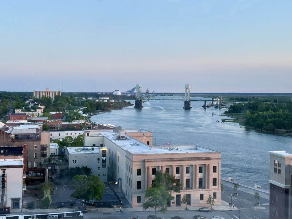
- To the south: Wilmington city neighborhoods such as Love Grove and Brooklyn, then downtown. The Isabel Holmes Bridge, a drawbridge that carries US 74/NC 133 over the Northeast Cape Fear, is just southwest.
- To the north: The Castle Hayne Road corridor toward Castle Hayne, with I-140 (the Wilmington Bypass) beyond.
- To the east: Wilmington International Airport (ILM) and the North 23rd Street / Kerr Avenue area.
- To the west: The Northeast Cape Fear River. US 421 runs up the other side of the river, and you reach it by crossing the Isabel Holmes Bridge.
County subdivision records inside or touching the Census boundary include Preservation Point, Council Heights and Arlington. Just north are areas that maps label Seitter Acres and Sedgefield. Hightsville has no official legal boundary, so listing sites draw it a little differently. Always go by the parcel record, not a website’s neighborhood label.
Moving to Wilmington?
Grab my free buyer guide to the Wilmington area. I’ll send it straight to your inbox, plus a few short emails on taxes, flood zones and how buying a home works here.
Homes in Hightsville
Housing here falls into two broad groups.
Older streets off Castle Hayne Road. Streets like Glendale Drive, Victoria Drive and Riverview Terrace have modest single-family homes. Recent sales included a 2-bed, 1-bath home of 862 square feet and a 3-bed, 1.5-bath home of 1,279 square feet (Redfin, sales closed July 2026). Manufactured homes are also part of the mix on some streets. Among parcels inside or touching the Census boundary, the middle half are between about 0.35 and 1.15 acres. The median is about 0.45 acre (New Hanover County parcel GIS, September 2026).
Preservation Point. This is a newer gated community on the Northeast Cape Fear River, off Castle Hayne Road. The county records it as a 150-lot subdivision. It’s marketed with a community marina, pool, clubhouse, fitness center and kayak launch. It includes custom single-family homes, townhomes and vacant lots, and some homes are three stories or have elevators. Before you make an offer, get the current HOA dues, the rules and the boat-slip terms directly from the HOA. Also check each lot’s flood zone (more on that below).
Market snapshot
Redfin reports a median sale price of about $292,400 for Hightsville over the three months ending September 2026. That’s based on very few sales (Redfin counted 4 in September), so one riverfront or manufactured-home sale can move the number a lot. For a steadier benchmark, the whole 28401 ZIP code had a median sale price of $379,389 in September 2026, with 92 homes sold and a median of 70 days on market (Redfin). I’ll pull live MLS comps for any specific street you’re considering.

Taxes, utilities and flood risk
Property taxes
New Hanover County’s GIS shows Hightsville as unincorporated. That means no City of Wilmington tax. For FY 2026–27, the county adopted a rate of 30.6 cents per $100 of assessed value. The unincorporated Fire Service District adds 7.25 cents, for a total of 37.85 cents per $100. On a home assessed at $300,000, that’s about $1,136 a year. Inside Wilmington city limits, where the combined county and city rate is 63.75 cents, the same home would owe about $1,913. Unincorporated properties also pay a county stormwater fee of $6.14 per equivalent residential unit per month.
Wilmington city limits run along the southern edge, so some nearby parcels are inside the city. Check the tax bill or the county’s parcel record for the exact address.
Water and sewer
Cape Fear Public Utility Authority (CFPUA) runs public water and sewer in this part of the county. Service still depends on the property, so confirm it in CFPUA’s Service Availability map. If a home isn’t connected, ask about any well and septic system and get them inspected. For vacant lots, CFPUA says to contact its Development Services team to confirm service.
Flood risk
Flood risk is the biggest thing to check here, and it depends a lot on the exact spot. I checked FEMA’s National Flood Hazard Layer in September 2026. Points I checked on the river side, including the Preservation Point area, fall in Zone AE with a base flood elevation of 9 feet. Points I checked farther east, including along Castle Hayne Road, were in Zone X (minimal flood hazard). First Street’s model, shown on Redfin, estimates that 72% of Hightsville properties (234) face severe flood risk over the next 30 years. That model includes risk outside FEMA’s mapped zones.
For any address, look it up on FEMA’s Flood Map Service Center and NC FRIS. Ask for an elevation certificate if the home is in or near an AE zone. The good news: unincorporated New Hanover County takes part in FEMA’s Community Rating System at Class 7. Under FEMA’s discount schedule, that’s a 15% discount on National Flood Insurance Program (NFIP) premiums for policies in special flood hazard areas. The City of Wilmington is not in the Community Rating System. Get flood and homeowners insurance quotes before your due diligence period ends.
Parks and outdoor life
- Northern Regional Park at Castle Hayne (4700 Old Avenue, Castle Hayne). This county park has 4 lighted football/soccer fields, 6 pickleball courts, an 18-hole disc golf course, a 1.7-mile asphalt walking trail, a playground and reservable shelters. The county is adding two more multi-purpose fields and a pump track, with opening expected in early fall 2026.
- Smith Creek Park (633 Shenandoah Street, off Gordon Road). It has a lake with a fishing pier, a small-boat launch and a 1.3-mile paved lake loop. The Phase 2 expansion opened on August 4, 2026. It added 85 acres, a one-mile paved perimeter trail and a second entrance at 251 Lake Emerald Drive East.
- Blue Clay Park (3840 Juvenile Center Road, Castle Hayne). The county lists about 8 miles of mountain bike trails for beginner to advanced riders.
- Downtown: The Riverwalk and New Hanover County’s Main Library, which opened at 230 Grace Street in October 2025, are a short drive south.
If you like to paddle or fish, the Northeast Cape Fear River is right here. Riverfront lots and community marinas are the easiest way onto the water. Check tide and water-depth limits with the HOA or a local marine contractor before you count on a boat slip.
Getting around
The MLK Parkway (US 74) interchange at Castle Hayne Road is the main connection. It takes you east toward College Road and Market Street, or west over the Isabel Holmes Bridge toward Leland. Typical drive times, depending on traffic:
- Downtown Wilmington: roughly 5–10 minutes
- Wilmington International Airport: roughly 5–10 minutes
- Castle Hayne and Northern Regional Park: roughly 10–15 minutes
- Leland: roughly 15–20 minutes
- Wrightsville Beach: roughly 20–30 minutes
Road projects to watch:
- U-5792 (College Road at MLK Parkway). This NCDOT project would turn the College Road/MLK Parkway intersection into an interchange with a flyover bridge and widen College Road between Market Street and Gordon Road. NCDOT’s January 2026 handout lists right-of-way work starting in summer 2026 and construction in summer 2029 (subject to change). That’s the route east from Hightsville toward Market Street and Northchase.
- U-5863 (Castle Hayne Road). This is a planned widening of NC 133 from I-140 south to Division Drive, at Hightsville’s north end. I couldn’t confirm a current construction date, so check NCDOT’s project pages before you assume a timeline.
Schools
Hightsville is served by New Hanover County Schools. School assignments are set by address and can change, so confirm the current assignment for any home with the district’s School Locator before you buy.
Is Hightsville a good match for what you want?
Hightsville may be a good match if you want:
- A short drive to downtown and the airport, with an unincorporated tax rate (37.85¢ per $100 for FY 2026–27 instead of 63.75¢ inside the city)
- Lots around half an acre, which is the median for parcels in the Census area (county parcel data, September 2026)
- River access through a gated waterfront community with a marina
- Quick access to MLK Parkway toward Leland, Market Street and I-140
It may be less of a fit if you need a property with no part in a mapped flood zone, or a long record of neighborhood-level sales to price from. With so few sales, comps often have to come from nearby ZIP-level data.
Keep researching: compare areas in Wilmington’s neighborhoods and places to live near Wilmington. Use my neighborhood research checklist. Read up on flood zones in Wilmington, county vs. city taxes, homeowners insurance costs and Wilmington water quality. Check the 2026 road projects and the full guide to buying a home in Wilmington.
Frequently asked questions
Is Hightsville inside Wilmington city limits?
No. Hightsville is an unincorporated census-designated place in New Hanover County, and the county’s municipal-limits GIS shows it outside Wilmington. Homes still use a Wilmington 28401 mailing address. City limits border it to the south, so confirm the jurisdiction for each parcel.
Where exactly is Hightsville?
Hightsville is on the east bank of the Northeast Cape Fear River, north of downtown Wilmington. It’s centered on Castle Hayne Road (NC 133) where it meets the Martin Luther King Jr. Parkway (US 74). The Census Bureau puts it at about 1.46 square miles of land.
What is the property tax rate in Hightsville?
For FY 2026–27, unincorporated New Hanover County properties pay the county rate of 30.6 cents plus the Fire Service District rate of 7.25 cents, for 37.85 cents per $100 of assessed value. That’s about $1,136 a year on a $300,000 assessment. Unincorporated properties also pay a stormwater fee of $6.14 per month per equivalent residential unit.
Is Hightsville in a flood zone?
Parts of it are. FEMA maps the riverfront side, including the Preservation Point area, as Zone AE with a 9-foot base flood elevation. Areas farther east along Castle Hayne Road were mapped Zone X when I checked in September 2026. Check each address on FEMA’s Flood Map Service Center and NC FRIS.
What parks are near Hightsville?
Nearby county parks include Northern Regional Park at Castle Hayne (athletic fields, pickleball, disc golf and a 1.7-mile trail), Smith Creek Park (a lake loop plus an 85-acre expansion that opened in August 2026) and Blue Clay Park (about 8 miles of bike trails). Downtown’s Riverwalk and Main Library are a short drive south.
Want to see homes in Hightsville or compare it with Castle Hayne or downtown? I’ll pull the flood zone, tax math and recent comps for the exact addresses you like. Call or text Tabi: 910-983-8963 · www.makingilmhome.com
Nearby Neighborhoods
Head north on Castle Hayne Road to Castle Hayne, south to Downtown Wilmington, or east to Northchase.

Hey, I’m Tabi! I help people buy and sell homes all over the Cape Fear coast, from New Hanover to Brunswick and Pender. If Hightsville is on your list, I’d love to show you around and pull real numbers for the streets you like. No pressure, just honest answers.
Talk soon,
Tabi
Tabetha Klein, REALTOR® | Coldwell Banker Sea Coast Advantage
Tabetha Klein, REALTOR® | Coldwell Banker Sea Coast Advantage · 910-983-8963 · www.makingilmhome.com. Each office is independently owned and operated. Equal Housing Opportunity. Figures reflect sources available as of October 2026 (U.S. Census Bureau, New Hanover County, FEMA, NCDOT, CFPUA, Redfin/First Street; Redfin market data three months ending September 2026) and change often. Verify taxes, utilities, flood zone and school assignment for any specific property. This page describes places and public amenities only.
Sources: U.S. Census Bureau geocoder (Hightsville CDP) · NC 133 route description · NHC FY 2026–27 budget adoption · NHC municipal limits GIS · NHC subdivisions GIS · NHC Floodplain Management · FEMA Community Rating System · FEMA Flood Map Service Center · NC FRIS · CFPUA service area · Redfin Hightsville market · Redfin 28401 market · Northern Regional Park · Northern Regional Park improvements · Smith Creek Park Phase 2 opening · Blue Clay Park · NHC Main Library opening · NCDOT U-5792 handout (Jan. 2026) · NCDOT U-5863 · Federal Register: Isabel S. Holmes drawbridge · NHCS School Locator